Contact info:


Swiftly communicate trail information to all stakeholders — from groomers to trail riders.

Manage maintenance and agreements much more efficiently.
Grow revenue streams with increased membership, permit sales, and sponsors.
Centralize and control work for your entire team — from local to regional levels.

Digitalize your entire trail network confidently and hassle-free.
Personalized experience
Route planning, saving favourite trails, recording journeys, and easy sharing with others.
Offline navigation — no connection required
Uninterrupted access to trail maps and easy-to-find services like food, accommodation, and gas.
Exclusive perks
Exclusive mobile app features and offers with a yearly subscription upgrade.
Community engagement
The latest updates about clubs, events, and other trail community initiative.
Real-time trail updates
Trail users get access to the most up-to-date trail conditions available.
Your web and mobile app platform hub for managing trails.

 Add, edit, close, or delete trails with a few clicks.
Import existing trail data swiftly — just drag and drop.
Inform riders with live trail statuses, POIs, and nearby services.
Connect the field and office — from maintenance to inspection.
Add, edit, close, or delete trails with a few clicks.
Import existing trail data swiftly — just drag and drop.
Inform riders with live trail statuses, POIs, and nearby services.
Connect the field and office — from maintenance to inspection.
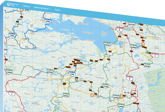
Trail Manager
Your web and mobile app platform hub for managing trails. Add, edit, close, or delete trails with a few clicks.
Import existing trail data swiftly — just drag and drop.
Inform riders with live trail statuses, POIs, and nearby services.
Connect the field and office — from maintenance to inspection.
Put your trail network on the map — and in the hands of your riders.
Customized to your organization’s branding.
Available online and offline navigation.
Exclusive real-time trail status, POIs, events, and more.
Generate revenue for your association.
Public Mobile App
Put your trail network on the map — and in the hands of your riders. Customized to your organization’s branding.
Available online and offline navigation.
Exclusive real-time trail status, POIs, events, and more.
Generate revenue for your association.
Showcase your trail network on web browsers for anyone not using the Public Mobile App.
Easily accessible from your website.
Exclusive real-time trail status, POIs, events, and more.
Trail information available through different map views.
Riders can plan and share their itineraries.
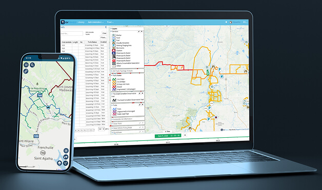
Interactive Web Map
Showcase your trail network on web browsers for anyone not using the Public Mobile App. Easily accessible from your website.
Exclusive real-time trail status, POIs, events, and more.
Trail information available through different map views.
Riders can plan and share their itineraries.
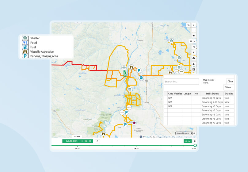
Your command centre for infrastructure and inspections.
Keep track of trail infrastructure — from culverts to turn signs.
View infrastructure on the map — see critical info in a click.
Stay on top of work with automated notifications.
Update info from the field with your mobile device.
Infrastructure & Inspection
Your command centre for infrastructure and inspections. Keep track of trail infrastructure — from culverts to turn signs.
View infrastructure on the map — see critical info in a click.
Stay on top of work with automated notifications.
Update info from the field with your mobile device.
Centralize all land agreements — no matter your trail network’s scale.
Locate agreements on the map and instantly view their status.
Apply filters to see only the information you need.
Get renewal alerts before agreements expire.
Keep a secure record of all permissions and documentation.
Landowner Management
Centralize all land agreements — no matter your trail network’s scale. Locate agreements on the map and instantly view their status.
Apply filters to see only the information you need.
Get renewal alerts before agreements expire.
Keep a secure record of all permissions and documentation.
Harness powerful insights to optimize your trail network operations.
Spot high-traffic areas in real time through the heatmap.
Maintain and upgrade trails proactively with trail traffic data.
Customize your view with filters by day, club or date range.
Support funding applications with data-backed reports.
Trail Analytics
Harness powerful insights to optimize your trail network operations. Spot high-traffic areas in real time through the heatmap.
Maintain and upgrade trails proactively with trail traffic data.
Customize your view with filters by day, club or date range.
Support funding applications with data-backed reports.
Go back in time at any time: access all historical data and changes.
Compare past and present trail layouts.
See what trails were open on specific dates.
Track updates by date, users, trail status, and more.
Restore previous versions as needed.
Historical Data & Time Machine
Go back in time at any time: access all historical data and changes. Compare past and present trail layouts.
See what trails were open on specific dates.
Track updates by date, users, trail status, and more.
Restore previous versions as needed.
Empower clubs and their volunteers to update their own trail data.
Delegate confidently to people with local knowledge.
Assign different access levels to clubs, volunteers, and teams.
Limit editing permission based on geographic zones.
Improve data security by controlling access on a geographic level.
Spatial Permission Control
Empower clubs and their volunteers to update their own trail data. Delegate confidently to people with local knowledge.
Assign different access levels to clubs, volunteers, and teams.
Limit editing permission based on geographic zones.
Improve data security by controlling access on a geographic level.
Trail Manager
Your web and mobile app platform hub for managing trails.
Public Mobile App
Put your trail network on the map — and in the hands of your riders.
Interactive Web Map
Showcase your trail network on web browsers for anyone not using the Public Mobile App.
Infrastructure & Inspection
Your command centre for infrastructure and inspections.
Landowner Management
Centralize all land agreements — no matter your trail network’s scale.
Trail Analytics
Harness powerful insights to optimize your trail network operations.
Historical Data & Time Machine
Go back in time at any time: access all historical data and changes.
Spatial Permission Control
Empower clubs and their volunteers to update their own trail data.
Trail Manager
Your web and mobile app platform hub for managing trails.
Add, edit, close, or delete trails with a few clicks.
Import existing trail data swiftly — just drag and drop.
Inform riders with live trail statuses, POIs, and nearby services.
Connect the field and office — from maintenance to inspection.
Public Mobile App
Put your trail network on the map — and in the hands of your riders.
Customized to your organization’s branding.
Available online and offline navigation.
Exclusive real-time trail status, POIs, events, and more.
Generate revenue for your association.
Interactive Web Map
Showcase your trail network on web browsers for anyone not using the Public Mobile App.
Easily accessible from your website.
Exclusive real-time trail status, POIs, events, and more.
Trail information available through different map views.
Riders can plan and share their itineraries.
Infrastructure & Inspection
Your command centre for infrastructure and inspections.
Keep track of trail infrastructure — from culverts to turn signs.
View infrastructure on the map — see critical info in a click.
Stay on top of work with automated notifications.
Update info from the field with your mobile device.
Landowner Management
Centralize all land agreements — no matter your trail network’s scale.
Locate agreements on the map and instantly view their status.
Apply filters to see only the information you need.
Get renewal alerts before agreements expire.
Keep a secure record of all permissions and documentation.
Trail Analytics
Harness powerful insights to optimize your trail network operations.
Spot high-traffic areas in real time through the heatmap.
Maintain and upgrade trails proactively with trail traffic data.
Customize your view with filters by day, club or date range.
Support funding applications with data-backed reports.
Historical Data & Time Machine
Go back in time at any time: access all historical data and changes.
Compare past and present trail layouts.
See what trails were open on specific dates.
Track updates by date, users, trail status, and more.
Restore previous versions as needed.
Spatial Permission Control
Empower clubs and their volunteers to update their own trail data.
Delegate confidently to people with local knowledge.
Assign different access levels to clubs, volunteers, and teams.
Limit editing permission based on geographic zones.
Improve data security by controlling access on a geographic level.